


Tactical NAV
3.987.00 Reviews
App Specs
- Version
- 1.1.57
- Updated On
- License
- $8.99
- Downloads
- 10,000+
- Developer
- Jonathan J. Springer
- Categories
- Maps & Navigation
- Platform
- Android, iOS
Screenshots
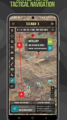
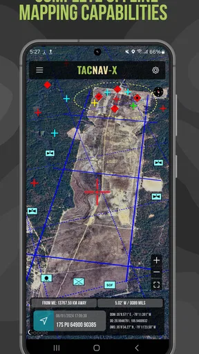
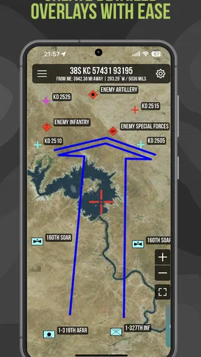
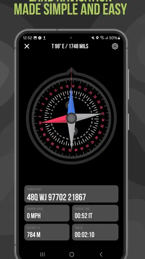
 Analysis by AppCompare
I look at Tactical NAV as a specialist tool rather than a replacement for the maps app most people use every day. Its appeal is the focus on MGRS navigation and military-style field work, where a coordinate format and careful plotting can matter more than a familiar street route. That makes it an interesting choice for people who already know why they want those tools, but a less natural fit for someone who just needs directions across town.
A focused tool, not an everyday route planner
In the Maps & Navigation category, Tactical NAV stands apart from turn-by-turn driving apps by centering its purpose on tactical navigation. Jonathan J. Springer develops the app, and its military focus shapes the kind of user it is trying to serve. I would not choose it as my default for finding a coffee shop or avoiding traffic; I would consider it when working with grid coordinates, moving across open terrain, or preparing a route where bearings and waypoints are part of the plan.
That distinction is useful when deciding whether the learning curve is worthwhile. A standard map app usually offers familiar road labels and search, while a specialist navigation tool asks you to think more deliberately about position, direction, and destination. If those ideas are already part of your outdoor routine, that extra focus can feel practical rather than complicated. If not, the conventional option will probably get you moving faster.
Where the specialist approach can help
A concrete use case is a hike that leaves marked trails. Before setting out, I would treat the destination as a waypoint, check the route against the terrain, and make sure I can interpret the coordinates I plan to follow. On the ground, a compass-oriented workflow can be more useful than a road-focused screen when the path is not a named street. The key benefit is not that a phone becomes infallible; it is that the app is aimed at a different kind of navigation problem.
For a search party or a group moving through a large outdoor area, shared conventions matter as much as the screen. MGRS coordinates can make a location easier to communicate when everyone is comfortable with that format. I would agree on the coordinate system and destination before separating or changing plans, rather than assuming every person’s mapping app will display the same reference. That small preparation step can prevent a frustrating mismatch in the field.
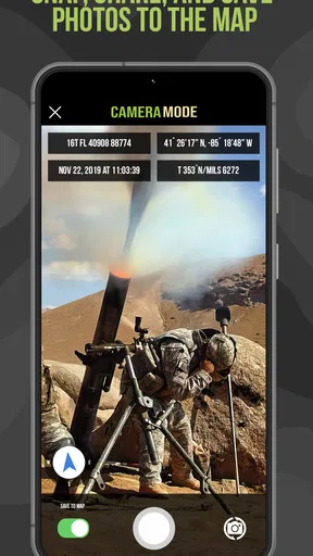
The augmented-reality view is best treated as a situational aid, not as a substitute for checking a bearing or understanding the map. A camera overlay can help connect what is on the screen with visible landmarks, especially when I am trying to orient myself quickly. But it depends on having a clear view and a steady device, and it can be harder to interpret in glare, poor visibility, or dense surroundings. I would use it to build context, then return to the map and compass for decisions that matter.
Practical trade-offs before you rely on it
Offline use is valuable when mobile coverage disappears, but it should not be confused with a guarantee that every part of a trip is covered automatically. I would prepare the phone and any relevant map information before leaving service, then test the workflow somewhere familiar. Battery life, device condition, and knowing how to read the screen remain the user’s responsibility; an app cannot remove those ordinary field risks.
Worth Reading Before You Choose

Baby Panda World Brings Quick Play to Modern Phones, but Its Game Library Feels Busy

ESPN’s Live Game View Makes Following Close Games Easier

QuizzLand Review: A Good Fit for Short Trivia Breaks, Not Every Player

Basketball Stars: Multiplayer Is Fast, but Can It Recover When Matches Go Wrong?

WEBTOON Turns Phone Updates Into a Better Reading Routine

Link to Windows Runs on Shared Habits, Not Social Feeds
There is also a real difference between a tool being designed for precision and a phone producing a perfect position in every environment. Buildings, trees, terrain, and device placement can affect GPS reception. For that reason, I would avoid making a safety-critical decision from one screen reading alone. Cross-checking with landmarks, a compass, and a sensible route plan is not needless caution here; it is part of using a tactical navigation app responsibly.
The app costs $8.99, with in-app purchases ranging from $3.99 to $24.99 per item. I would look carefully at what is included in the base purchase and whether any optional items match my intended use before spending more. At a 4.0 average from 147 ratings, it has a solid but not overwhelming reception; that gives me a little context, but it does not tell me whether a particular workflow will suit my needs.
Who should choose it
I see the clearest fit for people who already work with MGRS or want to learn a more deliberate field-navigation method: military users, experienced hikers, hunters, and outdoor groups with a specific need for coordinate-based planning. It may also appeal to technically curious users who enjoy preparing routes rather than relying only on automatic directions. The app has 10K+ installs, is rated for Everyone, and runs on Android 7.0 or later; its current version is 1.1.56.
I would steer casual drivers, city walkers, and visitors who mainly need searchable places or spoken turn-by-turn directions toward a mainstream maps app instead. Tactical NAV’s specialist emphasis is exactly what some people want, but it can be extra complexity for someone who never uses grid references, waypoints, or compass-based orientation. Likewise, anyone who expects a phone to replace map-reading skills or a backup plan should reconsider how they navigate, whatever app they choose.
For a realistic weekend scenario, imagine planning a route to a campsite beyond a marked trail. I would enter and verify the destination while I still had reliable connectivity, note the route’s key decision points, and tell someone where I intended to go. Before setting off, I would check that the phone is charged and that I can read the coordinates and compass display without fumbling. At a junction or an uncertain clearing, I would use the app to check position, then compare it with the terrain rather than following a line blindly. That workflow makes the tool useful without asking it to make every judgment for me.
One practical tip is to learn the app’s core actions in a low-pressure place before relying on them outdoors. Plot a waypoint, check how you read its coordinate, and practice switching between the map, compass, and camera view. A second is to agree on coordinate format with anyone you are navigating alongside; a precise location is only helpful if the other person can interpret it. These are small habits, but they make a specialist app easier to use when attention is already divided by weather, terrain, or group decisions.
What is Tactical NAV All About?
Let’s dive into the nitty-gritty. Tactical NAV is a military-grade navigation app that has been crafted to help you with real-time location tracking, waypoint plotting, and even augmented reality features. Think of it like having a mini command center right in your pocket.
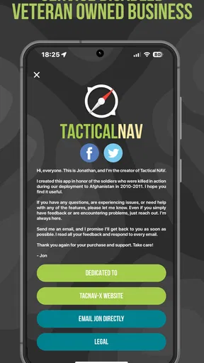
The app was designed by a U.S. Army veteran, so you know it’s built with a lot of insider knowledge and experience. It’s intended for both military personnel and outdoor enthusiasts who need precise navigation capabilities. It’s not just your average maps app; it’s a complete tactical toolset.
Features That Stand Out
This app is packed with features, and here are some that really stand out:
- Military-Grade GPS: This isn’t your everyday GPS. It’s designed for pinpoint accuracy, which is crucial when you’re out in the field.
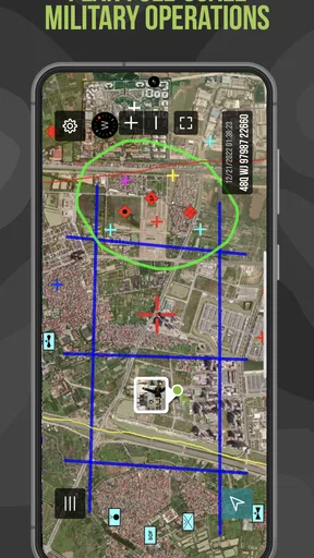
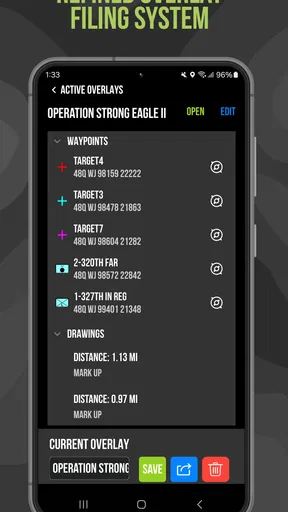
- Waypoints and Routes: Easily plot waypoints and routes, making navigation a breeze no matter where you are.
- Augmented Reality: Use the camera on your device to overlay information on your surroundings. It’s like having a HUD (Head-Up Display) in real life.
- Compass and Digital Maps: The app includes a reliable compass and digital maps to keep you oriented even in the most challenging conditions.
It’s these features that make Tactical NAV not just useful, but essential for anyone serious about navigation.
Getting Started with Tactical NAV
Now, when you first open the app, you’ll notice the interface is straightforward but packed with options. It might feel a bit overwhelming at first, but trust me, it’s worth taking a few minutes to explore all the settings. The tutorial is helpful, so don’t skip it if you’re new to this sort of tech.
The augmented reality feature is particularly cool. Just point your device and watch as it overlays tactical information onto your real-world environment. It’s like something out of a sci-fi movie, and it’s incredibly useful for getting a lay of the land quickly.
Who Will Benefit Most?
So you might be wondering, who is this app really for? Well, if you’re in the military, it’s a no-brainer. But let’s not forget about the outdoorsy types—hikers, hunters, and anyone who loves camping off the beaten path. It’s also a fantastic tool for search and rescue teams who need reliable navigation tools in their arsenal.
The app is designed for real-world use, which means it’s rugged and reliable. It even works offline, so you don’t have to worry about losing your way when you’re out of cell range.
Final Thoughts
In conclusion, Tactical NAV is more than just an app; it’s a tactical companion. If precision, reliability, and a bit of high-tech edge are what you’re after, this app is definitely worth checking out. It bridges the gap between cutting-edge technology and practical application in a way that feels seamless and intuitive.
So, if you’re ready to take your navigation skills to the next level, download Tactical NAV and see for yourself how it can change the way you navigate your world.
Pros
- Accurate GPS for precise navigation.
- User-friendly interface for quick access.
- Customizable map overlays available.
- Supports offline map usage.
- Military-grade compass functionality.
Cons
- Limited free version features.
- High battery consumption.
- Occasional map loading delays.
- No integration with other apps.
- Requires frequent updates.
FAQs for Tactical NAV
What is Tactical NAV and who is it designed for?
Tactical NAV is a military-grade GPS navigation app designed primarily for military personnel, veterans, and those involved in outdoor activities requiring precise navigation. It offers advanced mapping features, compass integration, and real-time tracking capabilities. Users benefit from its robust design, tailored for tactical operations and challenging environments.
Which features make Tactical NAV stand out from other navigation apps?
Tactical NAV stands out with its military-grade precision and user-friendly interface. Features include precise location tracking, waypoint marking, and custom map overlays. It also supports Military Grid Reference System (MGRS) and offers augmented reality capabilities for enhanced situational awareness, making it ideal for both field operations and recreational use.
Is Tactical NAV available for both Android and iOS devices?
Yes, Tactical NAV is available for both Android and iOS platforms. Users can download it from Google Play Store for Android devices and the Apple App Store for iOS devices. It ensures cross-platform compatibility, allowing users to access its features regardless of their preferred operating system.
Does Tactical NAV require an internet connection to function?
Tactical NAV can function without an internet connection, which is crucial for remote or off-grid locations. The app allows users to download maps for offline use, ensuring that navigation and tracking capabilities remain available even in areas with no cellular service. This feature is essential for military and outdoor enthusiasts alike.
Are there any in-app purchases or subscriptions in Tactical NAV?
Tactical NAV offers a one-time purchase model, eliminating the need for recurring subscriptions. However, some additional features or map packs may be available as optional in-app purchases. This pricing model ensures that users have access to essential navigation tools without ongoing costs, making it a cost-effective solution for professional use.


